GPR And Utility Detection

gpr and utility detection

GPR And Utility Detection

The GPR has been successfully used in a number of pavement subsurface investigations. Among the many applications where it has been found to be useful, its ability to measure pavement layer thickness with acceptable accuracy is the most important from the network-level pavement management perspective. It has also been used to locate voids beneath pavement, detect delamination, detect excess moisture, map underground utilities, conduct subgrade surveys, locate changes in pavement structure, and detect asphalt stripping.

Ground-Penetrating Radar (GPR)

With perhaps the best-funded ongoing research, GPR is another geophysical electromagnetic tool in the radio wave range. GPR works by sending an electromagnetic pulse into the ground. For utilities, the frequency range is typically between about 50 MHz and 500 MHz. Some ratio of this pulse signal is transmitted through boundaries and some ratio is reflected from the boundaries back to the receiving antenna. The boundaries are formed as a function of a particular particle’s dielectric properties. Overall propagation into the ground is a factor of power, frequency, and soil resistivity. In some ways then, GPR seems easier for an untrained technician to use in the field than pipe and cable locators, because GPR introduces fewer variables for the equipment operator to address. However, referencing the machine’s location becomes critical, and data interpretation becomes more difficult and time consuming, but attempts are being made to overcome these challenges to using GPR. With GPR, detection occurs when the utility’s dielectric constant differs from that of the surrounding soil. A dielectric constant that differs significantly from the soil around it would produce the best reflection. This occurs, for instance, when the utility is metallic and the ground is dry sand. Although pipe and cable locators might detect the same utility faster and cheaper and the result would be easier to interpret, GPR may perform better in those situations in which the utility is metallic but its joints are not, precluding a good circuit for the pipe and cable locator method. A small clay sewer pipe is not much different in dielectric constant than the surrounding soil.

If the pipe is empty, a reflection may occur at the pipe/air interface. If the pipe is filled with water and the surrounding ground is saturated, there will be little or no differentiating reflection. However, detection of a buried utility is constrained by the signal wavelength-to-pipe cross-sectional size ratio. This means that the smaller the utility, the higher the frequency needed to image it. Therefore, identifying a small utility becomes increasingly difficult the deeper it is placed. The diameter-to-depth ratio of a single fiber optic cable that is surrounded by soil with similar qualities—for instance, if it has no metal, very small air space, or plastic sheathing—makes such a cable virtually undetectable using GPR or anything else. A rule of thumb for the current technology in practice is that, under ideal conditions, a 12 to 1 depth-to-diameter ratio provides reliable utility detection down to the first 6 ft—that is, a 1-in. utility at a 1-ft depth, or a 3-in. utility at a 3-ft depth. Competent methodologies may improve this ratio. However, tightly spaced pavement reinforcing steel will effectively stop the penetration of any signal. Road deicing salt, which increases the conductivity of soil near roadways, may do the same. A very rough surface may create too much signal noise, effectively drowning out any signal. Highly conductive soil, as in areas with high iron content or in prepared roadway base material, will cause depth penetration problems, and utilities under salt water are virtually impossible to image, unless they are so large that a sufficiently low frequency can be used to penetrate the water. Such interferences preclude the imaging of any utility in certain conditions.

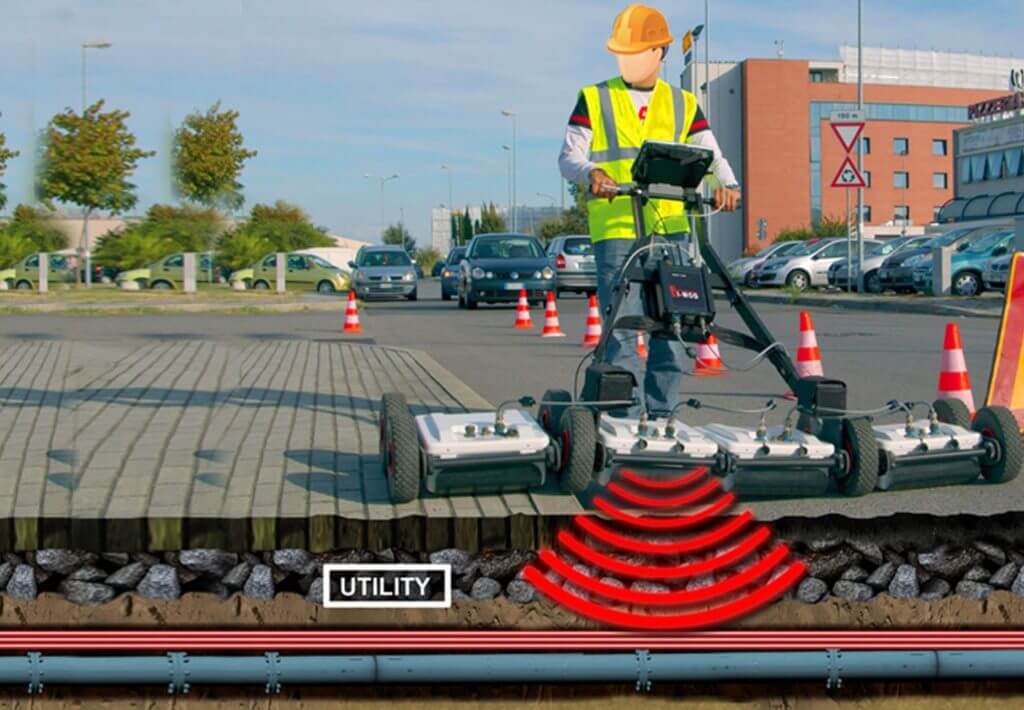
Yet, GPR has several advantages over pipe and cable locators. Its biggest advantage is that it can detect non-metallic utilities. A second advantage is that, even if the utility itself cannot be imaged, GPR can sometimes detect the sides or the materials of the trench in which the utility was placed. A third advantage is its depth determination. The radar data display is directly proportional to the electromagnetic wave’s speed in the soil. Given that the soil’s properties are relatively uniform and consistent in relation to wave speed, the depth of the utility can be easily measured. With a few test holes to calibrate wave propagation speed, the depth determination can be quite accurate and precise, as opposed to the variability and unreliability of the pipe and cable locator methods.

The GPR instrument must be pulled along a grid pattern while data is collected, unlike pipe and cable locators that produce a continuous EM signal output. It is important to keep the grid spacing small to collect enough data to “connect the dots,” especially in a utility-congested environment with many linear changes in utility direction. Grid spacing should not exceed the width of the antenna size or else there may be gaps in the data, and gaps in the data invariably result in guesses, which can lead to errors. Such grid spacing issues get insufficient attention from GPR users. Obstacles in the survey area can also present a significant challenge that could result in incomplete data. Recent research advances in data processing, GPS integration, laser-based referencing, data migration, multiple antenna arrays, stepped frequency capabilities, and image recognition software are in commercial development. These technological advances will help address GPR’s challenges, but they will not turn GPR into a total utility-detection and -tracing solution. The current state of the art has competent practitioners review each project site for adequate soil conditions and employ GPR when it is suitable. They use multiple frequencies and use GPR in conjunction with other techniques. A site appropriate survey and data referencing methods are selected. Data is collected in closely spaced parallel profiles and combined in a 3-D volume of data for postprocessing and time or depth-slice interpretation. While GPR is still rarely used for conventional locating, it is becoming more common as equipment costs drop and ease of use improves.

Cable and Pipe Locator (EPL)

The ultimate limit of detection range for any given line and signal frequency is set by receiver sensitivity, which is a function as much of filter quality as amplification capability and aerial design. How distant this limiting point is from the transmitter will vary with the line, the frequency, and also with the ability of the transmitter to impose a high signal current on it. This is a function not only of power but of impedance matching, as well as making sure of a good ground return path. Transmitter power requirements rise as the square of signal current, so impose cost, weight and battery life penalties, as well as the prospect of unacceptably high connection voltages for general usage if high currents are to be applied to high impedance lines. Cost-effective range optimization is therefore achieved by the choice of the signal frequency, transmitter current/ voltage options within battery life and operator safety limits, and above all in the quality of the receiver system in terms of dynamic range, that is to say the ratio of maximum to minimum signal level which it will process Accuracy of a locator, that is to say a locator’s ability to find the correct position of a buried line and its depth, is difficult to define and is often ignored. Electromagnetic locators do not locate pipes and cables; they locate alternating magnetic fields. Errors of accuracy can arise from two factors:

 l- The locator’s capability to measure the precise point at which a magnetic field is at a maximum (or minimum) and to correctly measure a field gradient.
Il- The cylindrical magnetic field around a line can be deformed or distorted so that the maximum value is no longer directly above the target line and the field gradient is not suitable for making an accurate depth measurement.

Frequency Selection

The choice of signal frequency is an important factor for effective tracing and identification of buried lines, and there is no single frequency that covers all conditions. For simple instruments to be used by relatively non-technical personnel, there is no option but to make a compromise, and choose a single frequency high enough to give good performance in the induction mode, but not so high that it will couple too easily into unwanted lines. Active signals between 8kHz and 33kHz are commonly used for these applications.

Typical services are offering of these and reasons for their use are illustrated overleaf:

512Hz

This low frequency is most useful for line tracing and identification over long distances. It does not couple easily to unwanted lines. but It is too low for induction, and it falls within the band of power frequency harmonic interference

8kHz

This medium frequency is the most useful general-purpose signal, high enough for induction, outside the power frequency interference band, and with limited coupling to unwanted lines. but It may not be high enough to impose a strong signal on small diameter line like telecom cables.

33kHz

This higher frequency is easily applied by induction to most lines, so is very useful for initial search. It travels well on small diameter lines. but It couples more easily to unwanted lines, and loses its strength over shorter distances than lower frequencies. 100kHz and over This very high frequency range deals with the difficult cases – induction onto small diameter lines in dry sandy soil, and short lengths of cable. It is very easy to apply by induction but It couples very easily to unwanted lines, and does not travel far.